What I'm talking about is an example like this, the Springfield, IL (KSPI) VOR/DME RWY 31:

Look at that leg starting at LATHA. It has the text "3100 NoPT to PUWGO 246 (7.9) and 296 (4.5)". It doesn't show a radial to fly off of LATHA, it just gives a heading. So what gives?
Instrument approach charts don't exist in a vacuum. Often to understand them, we must also refer to the appropriate enroute chart:
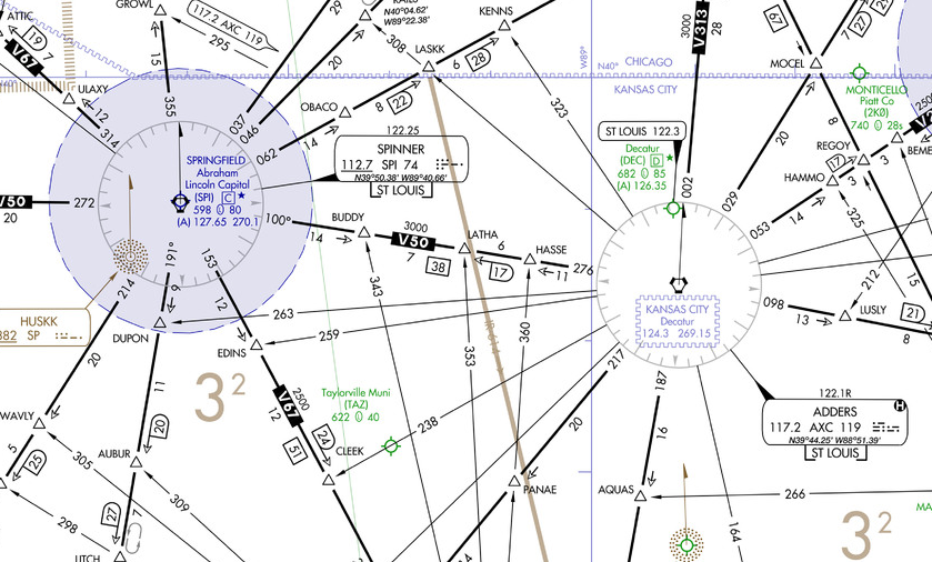
Notice that LATHA is sitting on V50 between AXC and SPI VORs, on the AXC R-276. To fly this approach, however, you are expected to fly heading 246 degrees from LATHA. This takes you OFF of the radial, and in fact you have no course guidance at all for this leg!
That's why it's called a "dead reckoning" leg. It's just a heading to fly. In this case, you will fly the heading 246 from LATHA until intercepting the SPI R-296 inbound on the approach. This should take about 7.9 nm according to the charted distance. Then you will fly another 4.5 nm on that R-296 until reaching PUWGO. The distances are approximate, of course, as wind drift will affect your actual track, but are there to give some idea of how long it should take for the intercept.
Notice there is a fix called (CFBVH) - with parentheses - at the intersection of the heading and the final approach course. This is known as a Computer Navigation Fix and is there solely for reference by GPS receivers and FMSes, helping them to align you on the proper course.
Now, you can imagine that with a 7.9 nm leg that has no course guidance, you could be pretty far off course if you have a strong crosswind - and you'd be right. Fortunately that is accounted for in the procedure design and the protected areas are HUGE, and get larger the farther away you get from the starting point.
You tend to find these more often on ILS procedures, as the localizer signal doesn't always point in a convenient direction. Two more examples are at Champaign-Urbana, IL (CMI) ILS or LOC RWY 32R (see the leg from NEWMY),

and the Salina, KS (KSLN) ILS or LOC RWY 35 (legs from both ANTON and GUTER).

There are many more examples, of course, but with ATC radar vectors, we fortunately don't have to fly them very often. Do you have any favorites? Let me know!