I've written about various types of departure procedures
before - VCOAs here and the option for Part 91 operators to take off in "0/0" conditions here.
But I recently received some questions from a friend and
reader based on a recent flight of his from Denton, Texas to McAlester,
Oklahoma (MLC) and returning, which you can read about on his blog at pilottangocharlie.blogspot.com. After stopping at MLC, he got his clearance
which consisted of the MLC VOR as the first fix. There were some real
instrument conditions around, so this was a for-real instrument departure. But
the only departure "procedure" that is published for MLC is a set of
takeoff minimums. He realized this situation wasn't covered real well in his
instrument training, and needed a little refresher on how this works.
I can sympathize! My
instrument training was in southeast coastal Virginia, where the flat terrain
makes Obstacle Departure Procedures (ODP's) purely an academic exercise for the
most part. Add in that radar coverage was excellent and most IFR releases
simply started with "Fly runway heading..." and the result was that ODPs
were not covered very well during my IFR training (in fact, they may not have been covered at all). In my experience this is pretty common, which is unfortunate
because every flight starts with a departure!
McAlester actually has a good example of a basic textual
obstacle departure procedure (or lack thereof):
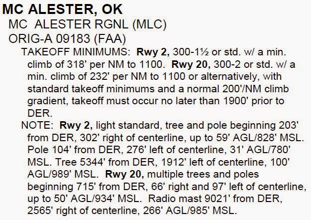
From Runway 2 it has a pretty typical set of takeoff
minimums or a minimum climb gradient. This situation I covered in my
"0/0" article, so I won't go into it here. But remember that
while these takeoff minimums aren't required for Part 91 operations, they are a
REALLY good idea.
From Runway 20 there are the same two options, plus a
third new one - the option to reduce takeoff distance by 1900 feet. This allows
the airplane to climb at a standard rate and still clear the nearby obstacle
with an acceptable safety margin. Obviously you would have to carefully plan to
make sure your airplane, on that day, given those weather conditions and
loading, can be off the ground by then. Seems like a small additional amount of
safety factor, and it is, but the reason for the shorter takeoff roll option is
just because some obstacle just barely penetrated the clearance surface and
this slight reduction resolves it.

This is a good time to note the "cross departure end
of the runway at least 35 feet AGL" wording in various training and
reference publications. This requirement has been removed from the TERPS - the
procedure design standards - but is still referenced in many FAA publications,
such as the Aeronautical Information Manual, para 5-2-8b1 and the Instrument Procedures Handbook, page 1-14. Both of these say
substantially the same thing:
"...required obstacle clearance for all departures,
including diverse, is based on the pilot crossing the departure end of the
runway at least 35 feet above the departure end of runway elevation..."
Which, while a good idea from a safety perspective, is not technically accurate any
longer. I believe the issue was one of planning - how do you determine whether
you can cross the departure end 35 feet high? Many light aircraft performance
charts give a 50-foot figure, but how do you extrapolate? So the standards were
revised to the easier-to-determine method of just getting airborne by the end
of the runway, unless otherwise specified.
Okay, so you took off, but now what?
In the MLC example, he was departing from runway 2, but
the first fix in his clearance was the MLC VOR to the south - behind him. How
to go about getting there?

In the absence of a departure procedure or specific ATC
instructions, the short answer is "however you want" (within reason
of course). There are only a couple of restrictions, both spelled out in the
same AIM paragraph linked above:
1. You climb on runway heading to 400 AGL before turning.
2. You keep climbing at the standard rate (200 feet per
nm) or as specified in the takeoff minimums up to your cleared altitude.
So in this case, the way to go would be to climb straight
ahead to a comfortable altitude, then turn direct to the VOR and proceed on
your cleared route. Depending on the ceiling and visibility, I might not turn
all the way around at 400 feet, though it should be safe to do so - a little
more altitude might be prudent in low IMC, plus it allows a little more time to
get turned around and tracking direct to the VOR, which is still very close
behind you.
This is what's known as a "diverse departure".
"Diverse" in this sense meaning "any direction", as there
are no restrictions placed on the pilot as far as routing goes. In
non-mountainous areas of the country like McAlester, Oklahoma, the safety of a
"200 feet per nm" climb gradient is evaluated out to 25 nm from the
airport. In mountainous areas, it's 46 nm. This is almost always enough to get
you on a published airway, above the OROCA, or into radar contact. And
if you're wondering what the definition of "mountainous area" is, the
FAA defines that as well in 14 CFR 95.
The map of the continental U.S. leads to some humorous
observations, like Scottsbluff, NE being considered mountainous. I suppose they
had to draw a line somewhere!

The great thing about takeoff minimums and departure
procedures is that you can always (and should always) review them, on the
ground, before even getting in the airplane. Once in flight you may have to
land at an unplanned airport, but I haven't yet heard of the takeoff happening
at a different airport!
No comments:
Post a Comment